Ooraminna Oaks: Unit Title Scheme Subdivision
Planning Institute Australia Award for Excellence
Abstract
Preceding urbanplan’s involvement in Ooraminna Oaks, a previous subdivision design and application for 86 lots received detailed criticism from the Department’s of Environment and Natural Resources and Infrastructure Planning and Logistics for failing address Planning Scheme provisions specifically relating to lack of application of the Land Suitability Assessment. In devising a scope for the design process that achieved a Planning Institute award for Excellence, Ian Brashaw Principal of urbanplan did four things:
- Examined the Departments’ Technical Assessment detailing criticism;
- Visited the site to inspection the landform;
- Referenced the January and May editions of the Land Suitability Assessments; and
- Held a meeting with all government agencies to confirm the direction forward.
The outcome was a site responsive design acknowledging the desert geomorphology, minimising environmental impact and creating a viable solution that avoided an obtrusive development footprint.
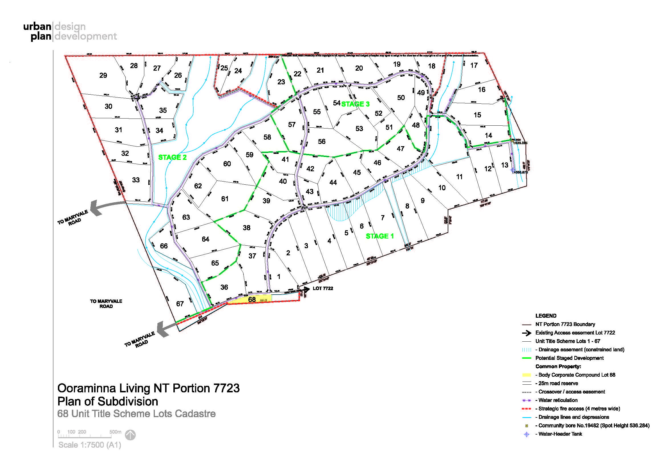
The project objective was to achieve a site responsive approach for the proposed rural living unit title scheme subdivision derived from land suitability and land capability criteria. Particular attention was given to minimising environmental impact and creating a viable design solution that avoided an obtrusive development footprint. The key issue was to accomplish a design response in a highly sensitive arid environment of Simpson Desert dunes.
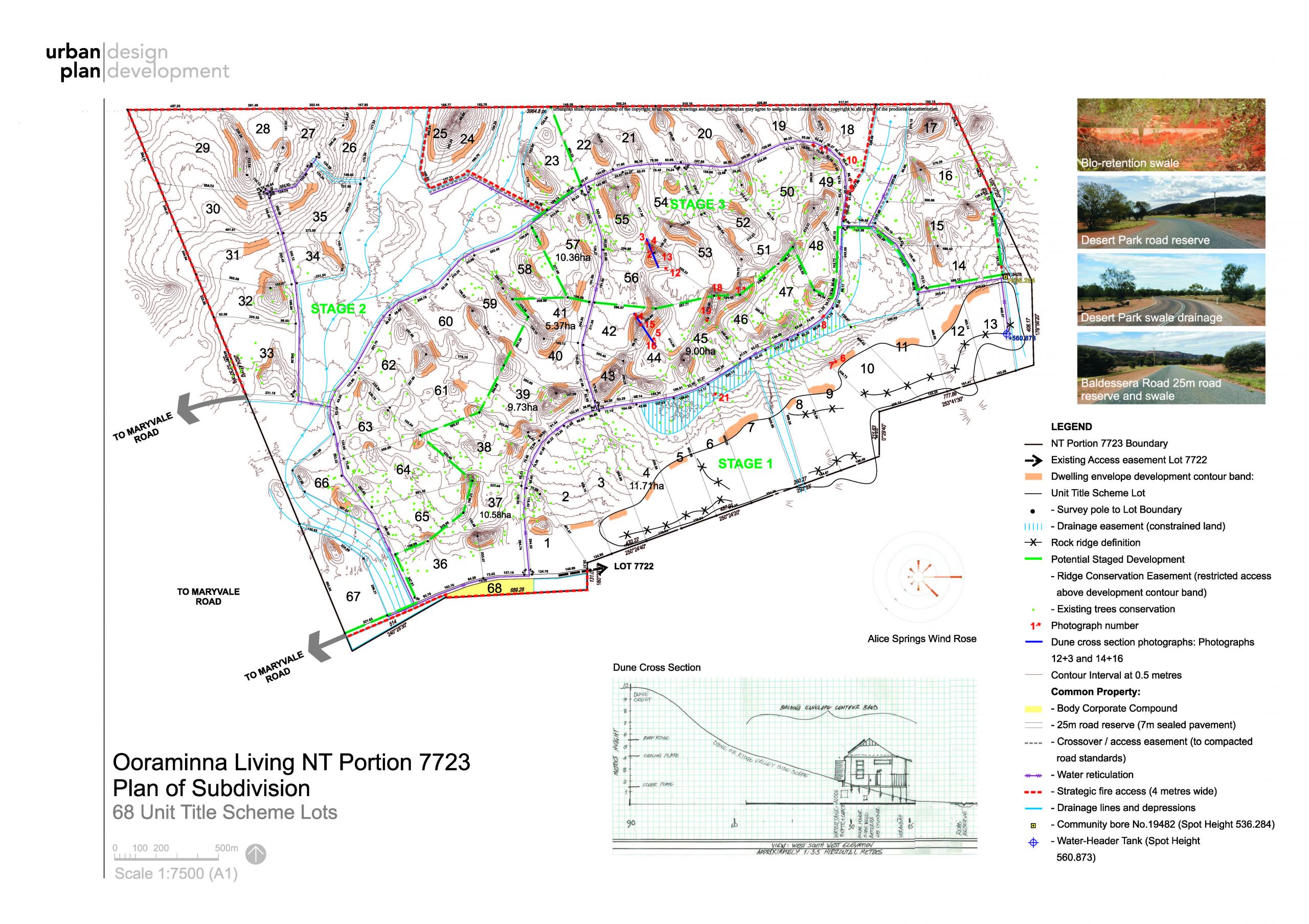
To initiate the project, the site’s geomorphology was scrutinised to address the land suitability and capability requirements (clauses 11.1 and 11.4 of the NT Planning Scheme and LSA Guidelines) to ensure that subdivision of unclassified land responds to the physical characteristics of the topography, soil, drainage and vegetation to accommodate wastewater systems within dwelling envelopes and post development stormwater flows. This informed the approach to the unit title scheme subdivision and enabled urbanplan to leverage the site survey and Land Suitability Assessment to achieve an environmentally sensitive site responsive design.
Stipulation of individual unit title property by-laws and provisions ensure restricted use permissibility on rural residential land. The Plan of Subdivision: 67 Unit Title Scheme Lots identifies specific siting of the proposed dwelling envelope for each unit title scheme lot and prevention of development elsewhere in the unit title scheme.
Building envelopes are sited. This enabled:
- Situating of dwellings and infrastructure on soil profiles capable of accommodating development;
- minimal environmental impact to achieve conservation objectives;
- minimal overlooking of neighboring dwellings; and
- siting dwellings to avoid cold desert southerly winds and to achieve views either across the dune landscape or toward MacDonnell Ranges.
The key initiatives achieved in this physically difficult environment are:
- Recognising the intrinsic and majestic beauty of the Simpson Desert dune landscape
- Working with the arid dune landscape to achieve an environmentally sensitive site responsive design
- Commencing the design process with the siting of dwelling envelopes within the development contour bands located in the mid to low contour range of the dune and rocky ridge valley-side slopes before lot boundaries were defined and road alignments positioned
- Dwelling placement to avoid cold desert southerly winds and enable views either across the dune landscape or toward MacDonnell Ranges
- Defining subdivision boundaries as dictated by dune crests
- Applying of survey boundary posts instead rural wired fencing